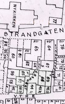
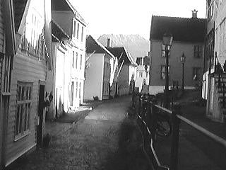
 Standing
at the highest point of Nordnes, on the hidden remains of the medieval convent,
Munkeliv, you can look straight down on Nykirken on the east side of Nordnes.
The area in between you and the church is the former middle class area, Ytre
Markevei, with the alleys Nykirkesmuget and Klokkersmuget.
Standing
at the highest point of Nordnes, on the hidden remains of the medieval convent,
Munkeliv, you can look straight down on Nykirken on the east side of Nordnes.
The area in between you and the church is the former middle class area, Ytre
Markevei, with the alleys Nykirkesmuget and Klokkersmuget.
By clicking on the map you will be able to explore this particular area of Nordnes, and enjoy the historical atmosphere and the wonderful scenery. We would like you to visit some of the houses to show you the change in appearance and give you an idea of how people lived over the years.
Thank you for joining us!
Hilde
Corneliussen
These
pages were made during the Bergen Summer school "New Methods in History" as
part of the World Wide Web course.
Afelonne Doek
Bente Opheim
We
would like to thank Geir Atle Ersland for providing us with useful information
about the area. We also used the 1801 census which is accessible throug the
Internet.